
CAZ510
Current watches, warnings, and advisories for East Bay Interior Valleys (CAZ510) CA
| CW9461-Clyde-Weather | |||
|---|---|---|---|
| LAST READING AT TIME: 14:40 DATE: July 30 2026, time of next update: 14:45 | |||
| Current Weather | Overcast and gloomy/Dry | Current Temperature | 88.2°F (31.2°C) (Heat Index 85.9°F ), Apparent temp 87.4°F , Apparent temp solar 87.4 °F |
| Maximum Temperature (since midnight) | 88.2°F at: 14:39 | Minimum Temperature (since midnight) | 61.2°F at: 05:50 |
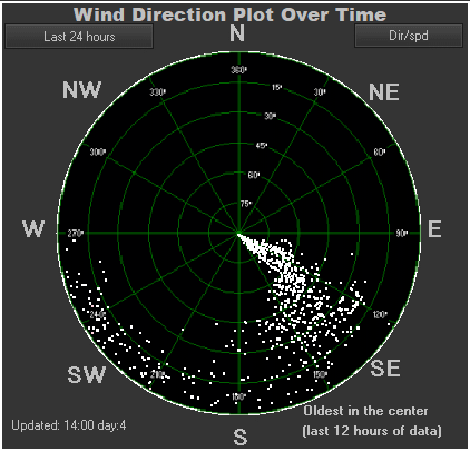
| Average windspeed (ten minute) | 4.7 mph | Wind Direction (ten minute) | WSW (255°) |
| Heat Index | 85.9°F | Maximum Gust (last hour) | 14.7 mph at: 14:34 |
| Maximum Gust (since midnight) | 16.1 mph at: 13:22 | Maximum 1 minute average (since midnight) | 9.6 mph at: 13:23 |
| Rainfall (last hour) | 0.00 in. (0.0 mm) | Rainfall (since midnight) | 0.00 in. (0.0 mm) --- |
| Rainfall This month | 0.00 in. (0.0 mm) | Rainfall To date this year | 7.35 in. (186.7 mm) |
| Maximum rain per minute (last hour) | 0.00 in/min | Maximum rain per hour (last 6 hours) | 0.00 in/hour |
| Yesterdays rainfall | 0.00 in | DewPoint | 52.9°F (Wet Bulb :67.4°F ) |
| Humidity | 30 %, Humidex 91.9°F | Barometer corrected to msl | 29.610 in. (1002.7 hPa) |
| Pressure change | -0.01 in. (last hour) | Trend (last hour) | STEADY |
| Pressure change (last 12 hours) | +0.02 in | Pressure change (last 6 hours) | -0.04 in |
| Current 00:00 hours of sunshine today, current sky: Overcast and gloomy | |||
| Sunshine hours for the year: | 00:00 hrs | Sunshine hours for the month: | 00:00 hrs |
| Current evapotranspiration 0.12 inches per day. Yesterday's reading 0.12 | |||
CONCORD BUCHANAN FIELD, CA, United States (KCCR) 38-00N 122-03W 11M
Jul 30, 2026 - 04:53 PM EDT / 2026.07.30 2053 UTC
Wind: from the W (270 degrees) at 9 MPH (8 KT) gusting to 20 MPH (17 KT):0
Visibility: 10 mile(s):0
Sky conditions: clear
Temperature: 89.1 F (31.7 C)
Dew Point: 43.0 F (6.1 C)
Relative Humidity: 20%
Pressure (altimeter): 29.91 in. Hg (1012 hPa)
Pressure tendency: 0.02 inches (0.7 hPa) lower than three hours ago
ob: KCCR 302053Z 27008G17KT 10SM CLR 32/06 A2991 RMK AO2 SLP114 T03170061 57007
cycle: 21
Date: 7/30/2026
Sunrise at:
06:09 am

Sunset at:
08:19 pm

Moonrise at:
08:45 pm 07/29/26

Moonset at:
07:07 am 07/30/26

First Quarter  July 21 2026
Full moon  July 29 2026
Last QuarterAugust 6 2026
New moon August 12 2026
Moon age: 15 days,9 hours,40 minutes,100%
Hours of possible daylight today was 14:10:00
Use the RELOAD facility on your browser to retrieve the latest data.